Israel - My Love

Israel Flag

Quotes About "Palestine"


Remember: Israel is bad! Its existence keeps reminding Muslims what a bunch of losers they are. ~~~~~~~~~~~~~~~~~~~~~~~~~~~~~~
"There will be no peace until they will love their children more than they hate us."

-Golda Meir-
~~~~~~~~~~~~~~~~~~~~~~~~~~~~~~
'If the Arabs put down their weapons today, there would be no more ‎violence. If the Jews put ‎down their weapons ‎today, there would be no ‎more Israel'‎

~Benjamin Netanyahu~
~~~~~~~~~~~~~~~~~~~~~~~~~~~~~~~
"Peace of us means the destruction of Israel. We are preparing for an all out war, a war which will last for generations.

~Yasser Arafat~
~~~~~~~~~~~~~~~~~~~~~~~~~~~~~~
"The Palestinian people have no national identity. I, Yasser Arafat, man of destiny, will give them that identity through conflict with Israel."

~ Yasser Arafat ~
~~~~~~~~~~~~~~~~~~~~~~~
"The Palestinian people does not exist. The creation of a Palestinian state is only a means for continuing our struggle against the state of Israel. For our Arab unity. In reality today there is no difference between Jordanians, Palestinians, Syrians and Lebanese. Only for political and tactical reasons do we speak today about the existence of Palestinian people, since Arab national interest demand that we posit the existence of a distinct 'Palestinian people' to oppose Zionism".

~ Zahir Muhse'in ~
Showing posts with label Fun. Show all posts

Tuesday, July 20, 2010

1,800 Years Old High-Level Aqueduct of Jerusalem Exposed Next to Jaffa Gate in the Old City

A beautiful aqueduct, standing 1.50 meters high and built of large stones, has been situated for almost two millennia right under one of the most familiar and traveled places in Jerusalem – beneath the road that leads from Jaffa Gate toward the David Citadel Museum and the shops on David Street.

The High-Level Aqueduct of Jerusalem, which dates from the second-third century CE, was exposed in excavations the Israel Antiquities Authority is conducting, with funding provided by the Jerusalem Development Authority for the purpose of replacing the infrastructure in the region.

According to Dr. Ofer Sion, excavation director on behalf of the Israel Antiquities Authority, “The side of the aqueduct was discovered during the course of the excavation. When we removed the stones in its side and peeked into it we saw a splendidly built aqueduct covered with stone slabs where one can walk crouched down for a distance of approximately 40 meters. It is very exciting to think that no one has set foot there for many hundreds of years”. According to Sion, “The noted Land of Israel scholar, Dr. Conrad Schick, described a specific section of the aqueduct in a survey he conducted at the end of the nineteenth century. In 1898 a building was erected in this area which afterward became what we know of today as the Imperial Hotel. Schick’s documentation provided us with the clue that led to exposing this section of the aqueduct”.

The aqueduct is c. 60 centimeters wide and 1.5 meters high. Shafts were exposed at fifteen meter intervals or so that allowed the ancients to check the state of the aqueduct from what was the surface level in those days.

Up until the end of the Second Temple period, in the first century BCE, Jerusalem’s water supply was derived from the Gihon Spring; however, as the number of residents steadily increased, the city’s water resources proved insufficient. The shortage of water was the principal factor that led to the construction of Jerusalem’s magnificent waterworks during Herod’s reign.

Gravity and very sophisticated engineering were employed to carry water to the city from springs located in the Hebron Hills, which were sufficiently high enough to convey the water by way of aqueducts to Jerusalem. The water was brought dozens of kilometers on its way to Jerusalem until it reached Solomon’s Pools and was distributed from there via two main aqueducts: the Low-Level Aqueduct and the High-Level Aqueduct. The High-Level Aqueduct conveyed water to the high part of the city where King Herod’s palace and Hezekiah’s Pool were situated, the latter being the main source of water for all those arriving in the city; and the Low-Level Aqueduct carried water to the Temple Mount and the Temple.

According to Dr. Sion, “For now, we can date the section of the aqueduct that was exposed to the second century CE, to the time of the pagan city Aelia Capitolina, which was built on the ruins of Jerusalem following the Bar Kokhba Revolt in 135 CE. Presumably, however, the aqueduct was first constructed in the days of Herod, as we know from other places along its route, particularly in the Bethlehem area. Archaeological research has shown that the total length of the aqueduct, which begins at Solomon’s Pools, is about 13 kilometers.

Israel Antiquities Authority


You might also like to read:

Jerusalem

For the First Time the Main Road of Jerusalem, from 1,500 Years Ago, is Exposed.

Other locations you might like:

Galilee & Upper Galilee

West Galillee

Golan Heights & Hermon Mountain

Costal Plain

Netania in Pictures

Jerusalem

Tel Aviv - Jaffa

The Negev

Holy Sites For Christians

For the First Time the Main Road of Jerusalem, from 1,500 Years Ago, is Exposed


An IAA Archaeological Excavation in the Heart of the Old City Confirms a Description on an Ancient Map: For the First Time the Main Road of Jerusalem, from 1,500 Years Ago, is Exposed

The excavations are being carried out at the initiation of the Jerusalem Development Authority, prior to rehabilitating the infrastructure

Madaba Map – an ancient mosaic map in a church in Jordan from the sixth-seventh century CE, which depicted the Land of Israel in the Byzantine period, explicitly showed: the entrance to Jerusalem from the west was via a very large gate that led to a single, central thoroughfare on that side of the city.

Various evidence of the important buildings in Jerusalem that appear on the map has been uncovered over the years or has survived to this day – for example the Church of the Holy Sepulcher – but the large bustling street from the period when Jerusalem became a Christian city has not been discovered until now. The reason for this is that no archaeological excavations took place in the region due to the inconvenience it would cause in stopping traffic in such a busy central location.

Now, because of the need for a thorough treatment of the infrastructure in the region, the Jerusalem Development Authority has initiated rehabilitation work and is renewing the infrastructure in this area in general, and next to the entrance to David Street (known to tourists as the stepped-street with the shops) in particular. Thus it is possible for both archaeologists and the public to catch a rare glimpse of what is going on beneath the flagstone pavement that is so familiar to us all.

From his knowledge of the Madaba Map, Dr. Ofer Sion, excavation director on behalf of the Israel Antiquities Authority, surmised that the place where the infrastructure will be replaced is where a main road passes that is known from the map. “And indeed, after removing a number of archaeological strata, at a depth of c. 4.5 m below today’s street level, much to our excitement we discovered the large flagstones that paved the street”. The flagstones, more than a meter long, were found cracked from the burden of centuries. A foundation built of stone was unearthed alongside the street on which a sidewalk and a row of columns, which have not yet been revealed, were founded. According to Dr. Sion, “It is wonderful to see that David Street, which is teeming with so much life today, actually preserved the route of the noisy street from 1,500 years ago”.

During the Middle Ages a very large building that faced the street was constructed on the stone foundation of the Byzantine period. In a later phase, during the Mamluk period (thirteenth-fourteenth centuries CE) elongated rooms were built inside this structure, some of which are vaulted; these were apparently used as shops and storerooms. It turns out that beneath this building – right below the street that runs between David’s Citadel and David Street and leads to the Armenian Quarter – is an enormous cistern, 8 x 12 meters and 5 meters deep, which supplied water to its occupants.

The Madaba Map is an 8 x 16 meter mosaic map that was built in a church in Madaba, Jordan and described the Land of Israel through the intimate knowledge the mosaic’s builder had of the country. The map depicts schematically all of the Land of Israel, with an emphasis on the Christian sites in it. Among other things that appear on the map are many of the churches they began to erect at this time when the city underwent a religious change from paganism to Christianity. The churches can be identified by the red roofs that are portrayed on the map.

The artifacts that were discovered in the excavations include an abundance of pottery vessels and coins and five small square bronze weights that the shopkeepers used for weighing precious metals.

Israel Antiquities Authority


You might also like to read:

Jerusalem

1,800 Years Old High-Level Aqueduct of Jerusalem Exposed Next to Jaffa Gate in the Old City.

Other locations you might like:

http://holylandandjudaism.blogspot.com/2010/07/israels-tourism-galilee-upper-galilee.html

http://holylandandjudaism.blogspot.com/2010/07/israels-tourism-golan-heights-hermon.html

http://holylandandjudaism.blogspot.com/2010/07/israels-tourism-coastal-plain.html

http://holylandandjudaism.blogspot.com/2010/07/israels-tourism-netanya-in-picture.html

http://holylandandjudaism.blogspot.com/2010/07/israels-tourism-jerusalem.html

http://holylandandjudaism.blogspot.com/2010/07/israels-tourism-west-galilee.html

http://holylandandjudaism.blogspot.com/2010/07/israels-tourism-tel-aviv-jaffa.html

http://holylandandjudaism.blogspot.com/2010/07/israel-tourism-negev.html

http://holylandandjudaism.blogspot.com/2010/07/holy-sites-for-christians-in-israel.html

http://holylandandjudaism.blogspot.com/2010/07/1800-years-old-high-level-aqueduct-of.html

Israel's Tourism - Galilee & Upper Galilee


Galilee
lsrael's Galilee, in the northern part of the country, is divided into a number of sections: Tiberias - center of the region's tourism and an ideal spot for relaxation and water sports fun. Around the Sea of Galilee -

55 kilometers in circumference, with places of interest like: Tabgha (site of the Miracle of the Multiplication of the Fish & Loaves); Capernaum (site of Simon Peter's house and the ruins of a 1500-year-old synagogue); Mount of the Beatitudes (where Jesus preached the Sermon on the Mount); . The Great Valleys of the Galilee (the Jordan and Jezreel Valleys) - site of Nazareth (the boyhood home of Jesus) and the Beit Shean Antiquities. Safed - center of 16th-century Jewish mysticism and present site of a modern Artists' Quarter. The Upper Galilee - characterized by breathtaking landscapes replete with woodland, mountains and streams.

* Afula - a medium sized town, not very interesting on itself, but it is the largest city in the Jezreel Valley
* Amirim - a vegetarian village
* Beth Shean - explore the remains of Canaanite, Egyptian and Romano-Byzantine cities
* Geva - a Kibbutz (small utopian settlement) founded in 1922 by Jewish immigrants from Poland and Russia
* Metula - known as being the northernmost populated place in Israel
* Nahariah - boasts the Montfort Castle, a crusader castle located in a beautiful forested area east of town
* Nazareth - the hometown of Jesus, now the largest Arab city in Israel
* Qiryat Shemona - town in the far north of Israel, the name translates as "the town of the Eight"
* Safed - this fascinating city is filled with artists and mystics, boasting home to ARI, who established Kaballah
* Tiberias - located on the western shore of the Sea of Galilee, a modern resort town with an ancient background

Other destinations:
* Belvoir Castle - a magnificently-located crusader castle located high above the Sea of Galilee
* Beth Shean Valley - the core of the north Jordan River valley
* Beth Shearim - Jewish catacombs from the Roman period
* Hazor - the largest ancient ruin in modern Israel
* Jezreel Valley - an extensive inland valley, largely rural, extending inland from east of Haifa to the Jordan Valley
* Megiddo - an ancient Canaanite and Israelite city and the location of several key battles, both ancient and modern
* Mount Meron - Israel's highest mountain, if excluding the Golan Heights, at 1208 meters above sea level with several hiking trails
* Sea of Galilee (Kinneret) - diverse landscapes and settlements around the lake, many with connections to the life of Jesus
* Zippori - an archaeological site with the best preserved mosaics in a Roman town

More:
* A number of Druze villages have an interesting and distinctive culture.
* Rabbi Shimon Bar Yochai is buried in the town of Meron, near Safed. Once a year on "Lag beOmer" (around May), hundreds of thousands of Israelis gather to Meron to celebrate the rabbi and his legacy of kabbalistic learning.


Main Cities:
Nazareth - City Guide

Nazareth of the Annunciation is the largest Arab city in Israel with a population of 60,000 - half Christians and half Moslems - living together in harmonious co-existence. It's geographic location, with Cana of the Wedding Feast and Sapphires (Tzippori) just next door, make it a perfect base from which to tour the rest of the Galilee It offers a uniquely different experience to the visitor. Picturesque red roofs and white stone churches ramble haphazardly down the slopes of this ancient Galilee hillside, the summit of which overlooks the panorama of the entire Jezreel Valley.

Nazareth, being one of the most important Christian holy sites in the world, has always been a very special haven for Christians & pilgrims. The visitor finds an exciting Middle Eastern ambiance with exotic flavors and textures, imbued with the famed warm and friendly hospitality of the Arab population, yet retaining many spiritual oases of serenity and peace provided by the diverse Christian orders in their beautiful Churches and Monasteries.


Tiberias - City guide

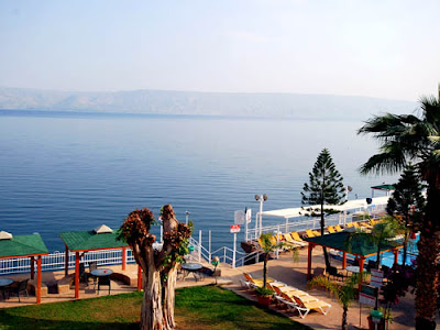
At an altitude of some 600 meters above sea level, overlooking the Sea of Galilee (the Kinneret), lies the city of Tiberias - one of the largest cities in the north of Israel and one of its most popular resort places. Tiberias has been the cultural and religious center of the Jewish community in the Roman days, and is considered one of the holiest cities in Israel. Alongside its historical monuments Tiberias is a lively place, especially during the hot summer months with many attractions for tourists and families with kids.

Hammat Tverya National Park is a recommended way to pass a relaxing afternoon while visiting the city. Situated next to the “Hamei Tverya” spa (another great option for spa lovers), the Hammat Tverya National Park includes few old synagogues and a public bath house, including few ancient natural warm water spas. Many of Tiberias’ landmarks of ancient history are located there.

The Tiberias beaches are mostly clean and well kept, though admission fee is required. To enjoy the scenic view of the Sea of Galilee from above mixed with a nice walk, visit the Emek Hayarden boardwalk between Zemach beach and the Dganya Aleph Kibbutz. The River Jordan (Yarden River), stretching to the North and South of the Sea of Galilee, has a wide selection of rafting and kayaking spots for water sports lovers. Along the Alon boardwalk, next to the beach, you can fine three centers offering equipment and water activities such as boats hiring, water skiing and more.

When getting tired of these activities, you might want to visit one of the fine seafood and fresh fish restaurants of Tiberias. On top of the promenade’s many sea food restaurants, you can try Shimshon steak house (behind the Tiberias market) or Dex steak house, both offer great meat at sea level with cool atmosphere. The Guy restaurant (next to Panorama hotel) is another off-the-beaten-track restaurant, serving kosher Jewish food from around the globe.

There are many hotels in Tiberias, some of which are luxurious and some are less pricey and more common. The best hotels in Tiberias include Caesar Resort Hotel, the Scots Hotel, the Sheraton and Rimonim Galei Kinnereth, all located next to the shore and offer 5 star facilities. Other good options while searching for hotels in Tiberias are the Holiday Inn, the Golden Tulip and Golan hotel, which is a simpler yet clean option and offers great views of the Sea of Galilee.


Safed (Tsfat - Tzfat) - City Guide
is a city in the Galilee region of Israel, and is one of the oldest centers for Jewish learning and spirituality, home to the Kabbalah movement which is popular with celebreties.

Located at an altitude of 900 meters (2,953 ft), Safed, is the highest city in the Galilee and of Israel. Due to its high altitude, Safed, experiences pleasantly warm summers and cold, and often snowy winters

It is the birthplace of the Kabbalah, and one of the main bastions for Torah study and the like during the centuries of Ottoman rule. It is one of the four holiest cities in Judaism, along with Hebron, Tiberias, and of course Jerusalem. While there are many stories about when it was founded, and by whom, it truly grew to prominence in the late 15th century when it became a refuge for Jews fleeing the Spanish Inquisition.

It is a cute, quaint city in the north of Israel. In more recent times, thanks to its beautiful setting surrounded by pine forests, and its agreeable, mild summers, Safed has developed into a summer holiday resort much frequented by Israelis and also foreign visitors. It has also become popular as an artists' colony apart from its religious significance, its nature and its pleasant summers.

See in Safed:
Synagogues - there are a number of old, beautiful, and unique synagogues in Tsfat, some of them rather famous world-wide among the Jewish community. These include:

* The Ari Ashkenaz and the Ari Sephard synagogues both in memory of Rabbi Isaac Luria. The Ari Ashkenaz is normally open for visitors on weekdays and boasts an ornate ark. The Ari Sephard synagogue is only open for prayers on the Sabbath.

* The "Abuhav" synagogue is probably the most unique, most beautiful, and most famous. It was built in the 1490's according to Kabbalistic architectural and spiritual beliefs.

* The "Caro" synagogue is another popular landmark, established in the 16th century on the site of a yeshiva run by one of the chief rabbis of Tsfat, and a compiler of the Shulchan Aruch, a book of Jewish law.

Both of these synagogues follow Sephardic traditions, and both, along with all the synagogues in Tsfat, and most around the country and the world, expect all visitors to be dressed appropriately; this means one must have legs covered (no shorts or short skirts), no bare shoulders/upper arms, and all men must cover their heads.

The Ancient Cemetery is the burial place of many famous Rabbis and is a common destination for visitors to Tsfat looking for answers to their prayers. Some famous Jewish personalities buried there include:

* The Arizal (Rabbi Isaac Luria), the famous kabbalist of the 16th century.

* Rabbi Joseph Karo, the author of the Shulchan Aruch, the definitive code of Jewish Law.

* Rabbi Moshe Cordevero (the Ramak), a famous kabbalist redating the Arizal.

* Chana and her seven sons, the martyred family from the time of the Temple.

Some other places to see in Tsfat that shouldn't be missed:
* Tzaddik Educational Visitor's Center featuring the Third Temple Model Exhibit and Multi-Media Presentation

* Great Breslov Synagogue

* Meiri Museum for Safed History

* Printing Press Museum

* Artist colony in the Old City

* Biblical Museum in the Fortress Garden

* Statue Garden and the Gallery of sculptor Moshe Ziffer

* The sephardic Ari Synagogue

* The Ari mikve

* The city also boasts a growing number of small, private art galleries, many of which have little cafes or tourist shops attached, selling postcards, t-shirts, and other basic tourist goods.

* Livnot U'Lehibanot, Rehov Alkabetz 17, ☎ (050)8939-042, [5]. Most tourists try to stop in the Tzfat Tourist Information Center for their first overview of Tzfat. The Center provides maps and guidebooks as well as information about tour guides, accommodations, and other information for Tzfat. There is a 10-minute movie that gives an overview of the History of Tzfat, as well as 800-year-old antiquities which, now uncovered, offer visitors an opportunity to see the original rooms and buildings of Tzfat of the 1300s and 1400s, which have been excavated by the Livnot U'Lehibanot Israel Experience Program.


Sites For Visit:
* Banias – Caesarea Philippi
* Sea of Galilee
* The Jordan River
* Capernaum
* St. Peter’s House
* Tabha
* Church of the Multiplication
* Basilica of Annunciation
* St Peter’s Primacy
* The Mount of Beatitudes
* Korazim
* Bethsaida
* Kursi
* Nof Ginossar
* Magdala
* Cana
* Nazareth
* St. Gabriel Church
* Church of St. Joseph
* Synagogue Church
* Precipice Mountain
* Mount Tabor
* Church of the Transfiguration
* Megiddo


You might also like to read:

http://holylandandjudaism.blogspot.com/2010/07/israels-tourism-golan-heights-hermon.html

http://holylandandjudaism.blogspot.com/2010/07/israels-tourism-coastal-plain.html

http://holylandandjudaism.blogspot.com/2010/07/israels-tourism-netanya-in-picture.html

http://holylandandjudaism.blogspot.com/2010/07/israels-tourism-jerusalem.html

http://holylandandjudaism.blogspot.com/2010/07/israels-tourism-west-galilee.html

http://holylandandjudaism.blogspot.com/2010/07/israels-tourism-tel-aviv-jaffa.html

http://holylandandjudaism.blogspot.com/2010/07/israel-tourism-negev.html

http://holylandandjudaism.blogspot.com/2010/07/for-first-time-main-road-of-jerusalem.html

http://holylandandjudaism.blogspot.com/2010/07/holy-sites-for-christians-in-israel.html

http://holylandandjudaism.blogspot.com/2010/07/1800-years-old-high-level-aqueduct-of.html

Israel's Tourism - Coastal Plain


Caesarea

Caesarea founded as a small Phoenician port city, eventually conquered by Alexander Jannaeus to be made part of the Hasmonean kingdom today it is one of Israel’s major tourist attractions and an increasingly popular place for Israel’s elite to make their homes. Aqueduct of Caesarea Virtual Tour Panorama >>

Caesarea offers an amazing visit to the national park and ancient port, a tour of the hippodrome and Roman amphitheater, a walk among the impressive palace ruins, walk the paths of the national park to see the sites and vistas, walk across from the artists yard, dine in one of the restaurants that offer a diversity of menus, join divers who dive to the historic underwater park and even stretch out on the golden sands that reach the port’s shores.


Caesarea beach
The Roman Theater of Caesarea in Israel is a well-preserved and fully restored theater built by Herod. Today, the amphitheater is not only a spectacular relic of the past, but a modern performing venue where concerts are frequently held. Inside the gate of the theater is a plaque with a replica (the original is in the Israel Museum in Jerusalem) of the inscription found during excavations in 1959-63.

During 2006 Israel had launched the world’s first underwater museum at Caesarea, Divers can now tour the sign-posted remains of the magnificent harbor built by King Herod to honor his Roman patron, Caesar Augustus. The site has been excavated over the last three decades.

If you want to stay in city the Dan Caesarea offers guests the luxurious ambiance of a country estate hotel. Set in fifteen acres of landscaped gardens, flanked by orange groves, banana plantations and an 18-hole golf course, it provides a gorgeous retreat for a fabulous vacation and is a much sought after venue for special events.


Netanya

Netanya, capital of the “Sharon” district, is located close to the seashores of the Mediteranean Sea, between “Poleg” stream and Wingate Institute in the south and the “Avichail” stream in the north. Natanya’s proximity to the sea (14 kilometers of one the most beautiful shores in the world) and its pleasant climate have made the city a most desirable tourist attraction and resort area.

Netanya, the largest city on the crossroads between Tel-Aviv and Haifa forms a connecting link between the northern and central parts of the country. Due to its central location near the Tel-Aviv - Haifa railroad tracks, 30 kilometers north of Tel-Aviv and 50 kilometers south of Haifa), Netanya has become a center for tourists as well as for shopping and industrial development. Three features have contributed to the development of Netanya as a city of tourism and leisure: beautifully maintained sea shores offering a variety of high standard services and the new beach elevator, a wide selection of hotels, (The King Solomon Hotel is a fine example) restaurants, bars and places of entertainment appealing to the national as well as the international tourist, and the central geographic location allowing easy access to tourist sites all over the country. Nearby services provide a wide variety of activities from nature walks for the whole family to sports such as paragliding, miniature plane flying, jeep tours, horseback riding and sail boating.

Official sea Beaches
There are 8 official lifeguard stations along the sea shore from Goldmintz beach in the south to Blue Bay Beach in the north. All stations have modern facilities with showers, sheds, first aid services and rented deck-chairs. Open from May until October. The central beach Sironit is open all year around. Free entrance.

Poleg Nature Reserve
South to Netanya is where Kids love to roll down and play on the sand dunes at the Nachal Poleg Nature Reserve. The reserve offers an interesting hike along the Poleg River, upstream to the point it meets the sea. The riverbanks are lined with eucalyptus trees, planted almost a century ago to help drain the swamps. In winter and early spring, the wildflowers along the route have made the Poleg Reserve a favorite destination for botanist where you’ll find a large concentration of Purple Iris blooming in February and March.

Netanya Is located Just 30 minutes drive from Tel Aviv, 40 minutes drive from Haifa and and hour and a half from Jerusalem.


Herzliya

Herzliya To the north of Tel Aviv is the modern resort city of Herzliya, which was named after one of the founders of the Zionist movement, Theodor Herzl. The city boasts some of the finest beaches in Israel and this, combined with the proximity to Tel Aviv, has made it popular with the country’s elite. The area near the beach, Herzliya Pituach, is home to many diplomats and wealthy Israelis.

Herzliya boasts two fine museums, the Founders’ House, which depicts the everyday life of the town’s first settlers, and the Herzliya Museum of Israeli Art & Sculpture Garden, which exhibits the work of contemporary Israeli artists.

Located in the heart of the country, Herzliya is one of the business and leisure centers of Israel. A 10 minute journey north of Tel Aviv along the Ayalon Highway or the number 2 road, Herzliya is connected by road and rail to all Israel’s major cities. The city’s liberal atmosphere and green environment attract visitors to Herzliya’s shopping malls, restaurants, bars and clubs day and night and especially on the Sabbath when stores and places of entertainment remain open.

Arena Shopping Mall
The Arena shopping mall is one of the newest and biggest shopping malls in Israel. Situated on the coast next to the Herzliya marina along with a good selection of stores, cafe’s, restaurants, and bars.
The Herzliya marina

Herzliya Marina
The largest marina in Israel, provides moorings for yachts of all sizes, including several berths for mega yachts up to 60 meters in length. The marina, which began operating in 1995, is a 15-minute drive north of Tel-Aviv, the country’s metropolis. The Herzliya Marina is centrally located alongside a glamorous front venue.


You might also like to read:

http://holylandandjudaism.blogspot.com/2010/07/israels-tourism-galilee-upper-galilee.html

http://holylandandjudaism.blogspot.com/2010/07/israels-tourism-golan-heights-hermon.html

http://holylandandjudaism.blogspot.com/2010/07/israels-tourism-netanya-in-picture.html

http://holylandandjudaism.blogspot.com/2010/07/israels-tourism-jerusalem.html

http://holylandandjudaism.blogspot.com/2010/07/israels-tourism-west-galilee.html

http://holylandandjudaism.blogspot.com/2010/07/israels-tourism-tel-aviv-jaffa.html

http://holylandandjudaism.blogspot.com/2010/07/israel-tourism-negev.html

http://holylandandjudaism.blogspot.com/2010/07/for-first-time-main-road-of-jerusalem.html

http://holylandandjudaism.blogspot.com/2010/07/holy-sites-for-christians-in-israel.html

http://holylandandjudaism.blogspot.com/2010/07/1800-years-old-high-level-aqueduct-of.html

Israel's Tourism - Golan Heights & Hermon Mount


Skiing season in Hermon:

The mount Hermon Ski resort is open for skiing and snowboarding & tubing. The Hermon mount is the only Ski resort in Israel and is a home for family fun. The Hermon is a vacation spot that can be enjoyed all year round. It is spread over an area of 5000 Dunams, at heights of between 1,600 – 2,040 meters above sea level.

Family Fun at the Hermon Ski Site
During the winter, the lower slopes are used for skiing and snowboarding,. Many visitors come to see the fabulous view, to enjoy and play in the snow, use the cable cars to climb up the mountain and to enjoy the various sports and activities that can be found at the site such as sledding.

If you want to stay close to the action, the Narkis Boutique Hotel, in the northern Golan Heights, is adjacent to Mount Hermon. It boasts stunning views and is a short distance from the Golan’s tourist attractions.

During the long summer months under the wonderful weather conditions of the high mountains, the site offers a variety of activities: take the cable car to visit the HaMa’apil summit including guided summer tours with introduction to the flora and fauna in the region, tours and explanations of the battle on Mount Hermon “The eyes of the state.” In addition you can enjoy the scenery of Mount Hermon by a ride on the “Extreme” mountain slides.


Main Sites:

* Qatzrin - the largest town

* Gamla - a site in the lower Golan that was a Jewish stronghold from 87 BCE until it fell to the Romans in 67 CE, nature reserve and archaeological site

* Nimrod Castle - a magnificently-located crusader castle located above the Sea of Galilee

* The Golan Heights is the wettest area in the region. There are many waterfalls including the Gamla, Sa`ar and the Banias waterfalls.

* It is especially recommended to visit in spring, when the ground is covered with wildflowers.

* Mount Hermon (2284m), in the northernmost point of the Golan Heights. There is a cable car going up the mountain - in the summer you can enjoy a breathtaking scenery and in the winter you can ski.

* Quneitra is a ghost town, evacuated during the 1967 war and left in the no-man's-land ever since. Thoroughly wrecked not only in 1967 but in the subsequent 1973 conflict as well, from the Israeli side the area can only be viewed from designated viewpoints set up along the border road, as it's just across the de-facto line of control. However, from Syria, the area can be visited with a permit from the relevant military office in Damascus, just above the Maliki garden on Sharia al-Jala (bring your passport). An official guide escorts all visitors (free of charge, but a tip is appropriate after the tour).

* Banias - This national park follows the Banias stream, and includes some easy and fairly short hiking trails that pass by old water mills, vigorous rapids, and the ruins of a temple to the god Pan.

* Majdal Shams - a Druze village. Nearby is the Shouting Hill where villagers communicate with their relatives in Syria.

* There are interesting hiking courses throughout the Golan. Breichat ha-meshushum (Hexagon pool) is a pool with natural hexagonal volcanic tiling. Yahudia wadi and Ein Zivan wadi are also popular hiking courses.


Golan Wineries

When you are planning to do some touring up in the Golan it is worth including a visit to some of the vineyards that have been planted in the volcanic soil that is unique to this area in Israel and learn about how grapes are grown and harvested. Follow up with a visit to a winery to learn about how wine is made. If you are really into wine I am happy to arrange a wine tour for you.

I think it’s fair to say that the Golan Heights winery founded in 1983 in the town of Katzrin, high up on the Golan Heights changed the world’s impression of Israeli wines and placed Israel firmly on the international wine map. Unique to Israel, the winery is owned by 4 kibbutzim and 4 moshavim. They manage 16 vineyards on the Golan (and one in the Upper Galillee), from Geshur and Nov which rise above the Sea of Galilee to Odem and El Rom below the snow-capped Mount Hermon, processing 6,000 tons of grapes and producing 6 million bottles of wine annually at 3 levels: Golan, Gamla and Yarden. They are also the parent of Galil Mountain Winery with Kibbutz Yiron.

I can arrange a tour of the facility including a visit to the oak barrel cellar, viewing of the bottling line (when in operation) and of course wine tasting.

Pelter Winery
Tal Pelter established his boutique winery in 2002, after studying enology in Australia, on the grounds of the family farm in Moshav Zofit near Kfar Saba where he produced four vintages of wine. During the summer of 2005 the winery was transferred to Kibbutz Ein Zivan adjacent to Merom Golan and resulted in a production of approximately 24,000 bottles. Pelter produces a sparkling wine in the traditional way, as well as 3 white wines, a Sauvignon Blanc, an unwooded Chardonnay and a Gewurztraminer, a first of this varietal for Pelter, described as “Sweet peach, liche, melon, citrus on a lively acidic background”. He also produces a series of red wines at two levels from Cabernet Sauvignon, Cabernet Franc, Merlot and Shiraz grapes grown on the Golan Heights and the hills of Jerusalem.

At the end of August 2005, Pelter supervised the planting of a new vineyard on the Golan, that he calls Vineyard of the Wind with a view of Mount Bental and the Hermon, 35 dunams (8.75 acres) of vines. Pelter is pursuing his dream of a quality winery on the Golan. I can arrange a visit to the facility for serious wine afficionados.

There are other small wineries on the Golan. In the midst of an ancient oak forest at Odem is the Odem Mountain Winery. Next to a natural spring is the Bazelet HaGolan winery and not far, the Assaf winery. Farther south you’ll find the Bashan Organic Winery and the Chateau Golan Winery. For a complete and up-to-date overview of the wine industry in Israel, I recommend Rogov’s Guide to Israeli Wines available at bookstores and the Internet.


You might also like to read:

http://holylandandjudaism.blogspot.com/2010/07/israels-tourism-galilee-upper-galilee.html

http://holylandandjudaism.blogspot.com/2010/07/israels-tourism-coastal-plain.html

http://holylandandjudaism.blogspot.com/2010/07/israels-tourism-netanya-in-picture.html

http://holylandandjudaism.blogspot.com/2010/07/israels-tourism-jerusalem.html

http://holylandandjudaism.blogspot.com/2010/07/israels-tourism-west-galilee.html

http://holylandandjudaism.blogspot.com/2010/07/israels-tourism-tel-aviv-jaffa.html

http://holylandandjudaism.blogspot.com/2010/07/israel-tourism-negev.html

http://holylandandjudaism.blogspot.com/2010/07/for-first-time-main-road-of-jerusalem.html

http://holylandandjudaism.blogspot.com/2010/07/holy-sites-for-christians-in-israel.html

http://holylandandjudaism.blogspot.com/2010/07/1800-years-old-high-level-aqueduct-of.html

Israel's Tourism - Netanya in Picture


You might also like to read:

http://holylandandjudaism.blogspot.com/2010/07/israels-tourism-galilee-upper-galilee.html

http://holylandandjudaism.blogspot.com/2010/07/israels-tourism-golan-heights-hermon.html

http://holylandandjudaism.blogspot.com/2010/07/israels-tourism-coastal-plain.html

http://holylandandjudaism.blogspot.com/2010/07/israels-tourism-jerusalem.html

http://holylandandjudaism.blogspot.com/2010/07/israels-tourism-west-galilee.html

http://holylandandjudaism.blogspot.com/2010/07/israels-tourism-tel-aviv-jaffa.html

http://holylandandjudaism.blogspot.com/2010/07/israel-tourism-negev.html

http://holylandandjudaism.blogspot.com/2010/07/for-first-time-main-road-of-jerusalem.html

http://holylandandjudaism.blogspot.com/2010/07/holy-sites-for-christians-in-israel.html

http://holylandandjudaism.blogspot.com/2010/07/1800-years-old-high-level-aqueduct-of.html

Israel's Tourism - Jerusalem

Welcome to the magical city of Jerusalem
Jerusalem is the modern Capital of Israel. Jerusalem is one of the most extraordinary cities in the world, presenting a unique combination of ancient history, spiritual sanctity and colorful cultures. Only a few cities inspire as much as Jerusalem.

King David Established Jerusalem 3000 years ago, Jerusalem is a fascinating city of many contrasts and diversities. It is a city where old and new, holy and secular, pure nature and beautiful architecture mix into magical harmony of smells, with many exclusive Jerusalem Hotels and also Jerusalem Apartments

Jerusalem is a holy city to three religions (Judaism, Christianity, and Islam), whilst being the modern capital of the State of Israel and the country`s largest city. The City of Gold, as it has come to be known in Hebrew, is a fascinatingly unique place where the first century rubs shoulders with the twenty-first century, each jostling for legitimacy and space, and where picturesque "old" neighborhoods nestle against glistening office towers and high-rise apartments. It is one of those places which has to be seen to be believed.

Districts
Jerusalem is a big place, and can be divided up into a few districts.
* The Old City and its Walls form a UNESCO World Heritage Site. This tiny ancient city is home to holy sites for Jews, Christians, and Muslims, and is truly breathtaking.
* West Jerusalem is the Jewish-Israeli part of Jerusalem, also known as New Jerusalem, it is the modern commercial heart of the city, having become the focus for development in the capital from the time of Israeli independence in 1948 to the reunification of the city with the Six Day War in 1967.
* East Jerusalem is the Eastern side of Jerusalem, home to most of Jerusalem's Arab population.
* Me'a Shearim is the area of Jerusalem inhabited largely by ultra-Orthodox Jewish people, moderate dress is required. The area looks like an old polish town from 1800.
* The german colony is a West Jerusalem neighborhood south-east of the city center. It's a wonderful place to drink coffee and to eat in restaurants. You may hear more "Anglos" speaking English than Hebrew on these streets.
* Ein Kerem is a (relatively) secluded neighborhood in West Jerusalem that maintains village atmosphere. It is surrounded by picturesque hills dotted with olive and cypress trees, home to artists and sculptors who have opened numerous galleries. Several churches are built on the site believed to be the birthplace of John the Baptist.
* Talpiot is a largely commercial and industrial neighborhood in the southern part of West Jerusalem.

Understand
Located in the Judean Mountains between the Mediterranean Sea and the Dead Sea, Jerusalem is considered holy to the three major Abrahamic religions: Judaism, Christianity, and Islam. It is the holiest city in Judaism and the spiritual center of the Jewish people since the 10th century BCE, the third-holiest in Islam and is also home to a number of significant and ancient Christian landmarks. It is also a city with a very violent past, as it has been fiercely contested between Christianity and Islam during the brutal Crusade era ). While the city has had a large Jewish majority since 1967, a wide range of national, religious, and socioeconomic groups are represented here. The walled area of Jerusalem, which until the late nineteenth century formed the entire city, is now called the Old City and became a UNESCO World Heritage Site in 1982. It consists of four ethnic and religious sections — the Armenian, Christian, Jewish, and Muslim Quarters. Barely one square kilometer, the Old City is home to several of Jerusalem's most important and contested religious sites including the Western Wall and Temple Mount for Jews, the Dome of the Rock and al-Aqsa Mosque for Muslims, and the Church of the Holy Sepulchre for Christians.

Surrounding the Old City are more modern areas of Jerusalem. The civic and cultural center of modern Israel extends from western Jerusalem toward the country's other urban areas to the west, while areas populated mostly by Arabs can be found in the northern, eastern and southern districts. Jerusalem became Israel's capital upon its independence and Jerusalem was united after the 1967 War when Israel captured East Jerusalem.

Archaeological findings prove the existence of development within present-day Jerusalem as far back as the 4th millennium BCE, but the earliest written records of the city come in the Execration Texts (c. 19th century BCE) and the Amarna letters (c. 14th century BCE). According to Biblical accounts, the Jebusites, a Canaanite tribe, inhabited the area around the present-day city (under the name Jebus) until the late 11th century BCE. At that point (c. 1000s BCE), the Israelites, led by King David, invaded and conquered the city, expanding it southwards and establishing it as the capital of the United Kingdom of Israel and Judah (the United Monarchy). It was renamed at this time as Yerushalayim (Jerusalem), a name by which it is still referred to today.

King David's reign over Jerusalem ended around 970 BCE when his son Solomon became the new king. Biblical sources state that within a decade Solomon started to build the first of two Holy Temples within city limits — Solomon's Temple (or the First Temple), a significant site in Jewish and Christian history as the last known location of the Ark of the Covenant. The period of the First Temple was marked by the division of the United Monarchy at the time of Solomon's death (c. 930 BCE) when the ten northern tribes, originally part of the Monarchy, split off to form the Kingdom of Israel. Under the leadership of the bloodline of David and Solomon, Jerusalem continued to act as the capital of the southern par of the split, the Kingdom of Judah. Later, with the Assyrian conquest of the Kingdom of Israel in 722 BCE, Jerusalem became the center of a Judah strengthened by the great number of Israeli refugees. In approximately 586 BCE, the Babylonians conquered the Kingdom of Judah including the city of Jerusalem, and the First Temple Period came to an end.

In 538 BCE, after fifty years of Babylonian captivity, the Jews were given permission from Persian King Cyrus the Great to return to Judah so they could rebuild Jerusalem and construct the Second Temple. The construction was completed in the year 516 BCE, seventy years after the destruction of the First Temple. Jerusalem regained its status as capital of Judah and center of Jewish worship for another four centuries, with a considerable portion of that period under Hasmonean rule. By 19 BCE, the Temple Mount was elevated and construction began on an expansion of the Second Temple under Herod the Great, a Jewish client king under Roman rule. In 6 CE, the city, as well as much of the surrounding Palestine, came under direct Roman rule as the Iudaea Province. Still unchallenged, the Roman rule over Jerusalem and the region came to an end with the first Jewish-Roman war, the Great Jewish Revolt, which resulted in the destruction of the Second Temple in 70 CE. Jerusalem once again served as the national capital for the people of the region during the three-year rebellion known as Bar Kokhba's revolt. The Romans succeeded in sacking and recapturing the city in 135 CE and as a punitive measure, the Jews were banned from Jerusalem.

In the five centuries following Bar Kokhba's revolt, the city remained under Roman and Byzantine rule. With the city controlled by Roman Emperor Constantine I during the 4th century, Jerusalem was transformed into a center for Christianity, with the construction of sites such as the Church of the Holy Sepulchre. For most of the time between Constantine's rule and the arrival of the Muslim forces in 638, Jews were banned from Jerusalem. From that point, the rights of the non-Muslims under Islamic territory were governed by the Pact of Umar, and Christians and Jews living in the city were granted autonomy in exchange for a required poll tax (jizya). When Caliph Umar first came to the city, he requested that Sophronius, the reigning Patriarch of Jerusalem, guide him and his associates to the site of the Jewish Holy Temple, whereupon he later decided to build a mosque. By the end of the 7th century, a subsequent caliph, Abd al-Malik, had commissioned and completed the construction of the Dome of the Rock over the Foundation Stone. In the four hundred years that followed, Jerusalem's prominence diminished as Arab powers in the region jockeyed for control.

In 1099, Jerusalem was besieged by the First Crusaders, most of the city's then 30,000 Muslim and Jewish inhabitants, were slaughtered. That would be the first of several conquests to take place over the next five hundred years. In 1187, the city was taken from the Crusaders by Saladin. Between 1228 and 1244, it was given by Saladin's descendant al-Kamil to the Holy Roman Emperor Frederick II. Jerusalem fell again in 1244 to the Khawarizmi Turks, who were later, in 1260, replaced by the Mamelukes. In 1517, Jerusalem and its environs fell to the Ottoman Turks, who would maintain control of after the First World War.

In 1917 after the Battle of Jerusalem, the British Army, led by General Edmund Allenby, captured the city. The League of Nations, through its 1922 ratification of the Balfour Declaration, entrusted the United Kingdom to administer the Mandate of Palestine and help establish a Jewish state in the region. The period of the Mandate saw the construction of new garden suburbs in the western and northern parts of the city and the establishment of institutions of higher learning such as the Hebrew University, founded in 1925.

As the British Mandate of Palestine was expiring, the 1947 UN Partition Plan (Part III) recommended "the creation of a special international regime in the City of Jerusalem, constituting it as a corpus separatum under the administration of the United Nations." However, this plan was never implemented and at the end of the 1948 Arab-Israeli War, Jerusalem found itself divided between Israel and Jordan (then known as Transjordan). The ceasefire line established through the 1949 Armistice Agreements between Israel and Jordan cut through the center of the city from 1949 until 1967, during which time West Jerusalem was part of Israel and East Jerusalem was part of Jordan. In 1949, west Jerusalem became Israel's capital.After the 1967 war, united Jerusalem became as Israel's capital.

Religion
In addition to many secular Israelis and foreigners, Jerusalem is considered home by large numbers of adherents to three of the four Middle Eastern monotheistic faiths: Judaism, Christianity, and Islam. Adherents of these faiths have tended historically to congregate in various neighborhoods of the city, with considerable overlap.
[edit] Language

Due to its ethnic make-up the main languages spoken in Jerusalem are Hebrew in West Jerusalem and Arabic in East Jerusalem. Most people throughout the city speak sufficient English for communication, particularly Jews that have immigrated from the US and Europe. Additionally, many Charedi (strictly Orthodox) Jews speak Yiddish, and there is a significant number of French-speaking Jews. Smaller groups of Jews speak Dutch and Spanish. There is a large number of Russian immigrants of Jewish background, so it is not uncommon to see signs in Russian or hear Russian language radio. Finding English speakers in West Jerusalem is not at all difficult, but English speakers in East Jerusalem are much harder to find except in Arab businesses near Jewish settlements and in areas trafficked by tourists, such as the neighborhoods surrounding Damascus Gate.

Climate
Located on the eastern edge of the Mediterranean Sea, Jerusalem has a Mediterranean climate with hot, dry summers and cool, wet winters.

Winters are very wet, with nearly all of Jerusalem's annual 590 mm (23 in) of precipitation occurring between October and April. The coldest month is January, with an average high of 12°C (53°F) and an average low of 4°C (39°F). Sub-freezing temperatures are not an everyday occurrence, but do happen, and the city will get occasional snowfall during the winter, though it usually only lasts a matter of hours rather than days. However, every once in a while the city will experience significant accumulating snow.

Summers are hot and dry as a bone with virtually no rainfall between the months of May and September. Temperatures will generally approach around 30°C (88°F) during the day and cool to around 15°C (59°F) at night. Being near the desert, there is often a big difference between the day and night temperatures, and even the hottest days can turn into chilly nights. Spring and fall are mild, with minimal rainfall and pleasant temperatures.

Jerusalem Archeological Park:

In the Jerusalem Archaeological Park, the glass doors of the Davidson Center, near the Western Wall - the last remnant of the Holy Temple - swish open silently to welcome you. When they close behind you, you enter another world. It is the world of Jerusalem’s glorious past, showcased through the prism of advanced visualization technology.

The center was built into the basement of an eighth-century building, scrupulously preserving and enhancing it. As you follow the winding ramp downward, artwork and archaeological finds take you back through the ages, and you’ll meet colorful figures of Jerusalem’s exploration in days gone by. A ten-minute, high-definition digital video ingeniously interchanges the experience of Second Temple pilgrims with that of present-day visitors.

The realization that the historic and spiritual treasures depicted – the Temple Mount, the Western Wall and the Southern Wall – still stand only a few strides away adds to the power of the presentation. The center’s highlight is a three-dimensional virtual reconstruction of the Temple, based on ancient writings and excavations, and produced by a team from the Department of Urban Simulation at UCLA. Pictures generated every 41 millionths of a second give participants the eerie feeling that they are really walking up the staircase to the Temple and through its towering colonnades to stand before the grandeur of the Holy of Holies.

The center maintains regular visiting hours for groups and individuals, and is closed on Saturdays. The virtual reconstruction session is part of a guided tour pre-arranged through the Davidson Center.


Sites For Visit:
* Garden of Gethsemane
* The Paternoster Church
* Church of Dominus Flevit
* Church of Agony
* Rock of Agony
* Grotto of Agony
* The Church of St. Mary Magdalena
* Mount of Olives
* Chapel of the Ascension
* Church of the Visitation
* Mount Zion
* Coenaculum
* Cave of John the Baptist
* Church of St. John the Baptist
* The Church of St. Peter in Gallicantu
* Church of the Holy Sepulcher
* The Monastery of the Cross
* The Dormition Abbey
* David's Tomb
* Yad Vashem
* Ein Karem
* The Western Wall
* Western Wall Tunnel
* Dome of the Rock
* Al-Aqsa Mosque
* The Pool of Bethesda
* Via Dolorosa


You might also like to read:

Jerusalem Archeological Park.

For the First Time the Main Road of Jerusalem, from 1,500 Years Ago, is Exposed.

1,800 Years Old High-Level Aqueduct of Jerusalem Exposed Next to Jaffa Gate in the Old City.

Other locations you might like:

http://holylandandjudaism.blogspot.com/2010/07/israels-tourism-galilee-upper-galilee.html

http://holylandandjudaism.blogspot.com/2010/07/israels-tourism-golan-heights-hermon.html

http://holylandandjudaism.blogspot.com/2010/07/israels-tourism-coastal-plain.html

http://holylandandjudaism.blogspot.com/2010/07/israels-tourism-netanya-in-picture.html

http://holylandandjudaism.blogspot.com/2010/07/israels-tourism-west-galilee.html

http://holylandandjudaism.blogspot.com/2010/07/israels-tourism-tel-aviv-jaffa.html

http://holylandandjudaism.blogspot.com/2010/07/israel-tourism-negev.html

http://holylandandjudaism.blogspot.com/2010/07/for-first-time-main-road-of-jerusalem.html

http://holylandandjudaism.blogspot.com/2010/07/holy-sites-for-christians-in-israel.html

http://holylandandjudaism.blogspot.com/2010/07/1800-years-old-high-level-aqueduct-of.html
Related Posts Plugin for WordPress, Blogger...

My Videos Bar

Breaking News